One of the minor perils of archive research is the rabbit holes! I certainly did not expect to fall into one about the early days of motoring…
While looking through early 20th century copies of Scottish Field – a magazine focused on outdoor activities such as hunting, shooting, riding and fishing for people with plenty of leisure time and money – I was mildly interested to see that it had a motoring column, with information on new cars, and racing and motoring events. But I was very intrigued by a small item in the May 1906 edition:
“A rather extraordinary invention was on exhibition at the Vienna Automobile Show, the object being to enable a driver to locate himself on his route at any hour of the day or night.”
Scottish Field, May 1906, pp 287
Yes, it’s an Edwardian ‘sat nav’!
Scottish Field goes on to quote the device’s marketing blurb:
“The apparatus, which is placed in front of the driver, is about the size of a cigar box and contains a map of the route to be taken printed on a broad band of paper on rollers. It shows not only towns and villages, but other points of special interest to automobilists, such as roadside inns, repair shops, benzene stations, and the like.
“By means of cords or flexible wires the apparatus is connected with the wheels of the motor and as the car progresses the map unwinds itself. The driver can see from the map just what part of the road he is going over, and what villages, etc. are in the neighbourhood. The Kartograph serves also as an infallible speed recorder, for the automobilist need only look at his watch and compare the time occupied in travelling between two points with the distance marked on the map.
“But the value of the Kartograph does not end here either. Awkward bends in the road and obstacles requiring caution are marked on the map by indentations in the paper made some 300 yards before they are reached. These indentations catch a lever which rings an electric bell, thus warning the driver of the obstacles before him. Finally, a small electric light placed under the transparent paper on which the map is printed makes the Kartograph as useful at night as by day, keeping the driver informed as to his exact whereabouts, in the darkest night or thickest fog.”
Scottish Field, May 1906, pp 287-288
Helping early motorists navigate
I haven’t yet found any more information about the Kartograph but in looking for it, I discovered that apparently it was just one of several early attempts to create in-car navigation devices that updated as a journey progressed.
According to electronic navigation pioneer Robert French, “Dozens of devices for automobile route guidance based on the odometer were patented by 1920. These pioneering devices incorporated route map information in various forms including sequential instructions printed on a turntable, punched in a rotating disk, and printed on a moving tape, all driven by an odometer shaft in synchronization with distance traveled along a route.” (French 2006, pg 267).
The first that he highlights was a ‘route indicator’ patented in the USA in 1909 by American Frank J Linden-Thaler and John Protz (from the Austro-Hungarian Empire) both living in New York State. This was:
“a guide device by which the route to be traveled is indicated to the chauffeur, so as to prevent thereby to a certain extent the necessity of making inquiries for the road to be taken, and also for facilitating the work of a chauffeur not conversant with the country and rendering thereby the owner of an auto mobile to some extent independent of the chauffeur..”
Google Patents
It displayed the map of your route on a strip of paper inside a case with a glass cover. This showed you how far along the route you were and which turnings to take to get to your destination. They envisaged that people could make their own maps for their own personal routes and buy prepared ones for unfamiliar journeys, though it doesn’t seem to have gone into production.

But they weren’t the first to have these ideas. Certain parts of their original patent application were deemed not original because of “unacceptable similarities to a patent awarded in Britain in 1904 and two other awarded in France the following year” (Monmonier, 2017, pg 71).
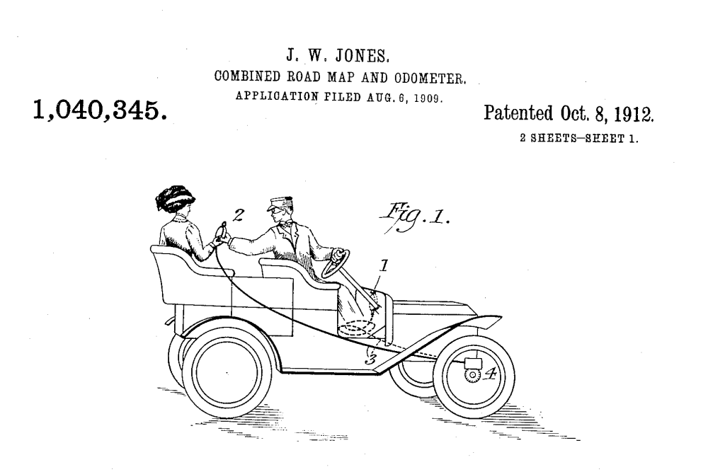
American Joseph W Jones, having invented and installed a ‘Speed-O-Meter’ in a car in 1901, applied for a patent for his ‘Combined Road Map and Odometer’ in 1909.
“My invention is designed to enable the automobilist to ascertain how far along on his journey he is, and to keep him posted generally as to the route; -to enable him to know how many miles he has already traveled and how many more remain to be traveled to reach his destination (or any other point on the route) to enable any occupant of the vehicle, even on a rear seat, to obtain the same information; and to enable the automobilist to make his own chart as he goes over a new route, or to substitute a new chart when desired.”
Google Patents
The patent showed how, as well as being attached on dashboard for the driver to consult, it could be used by a passenger in the back seat.
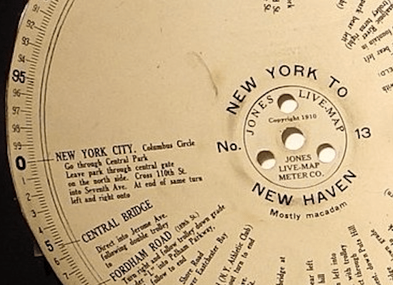
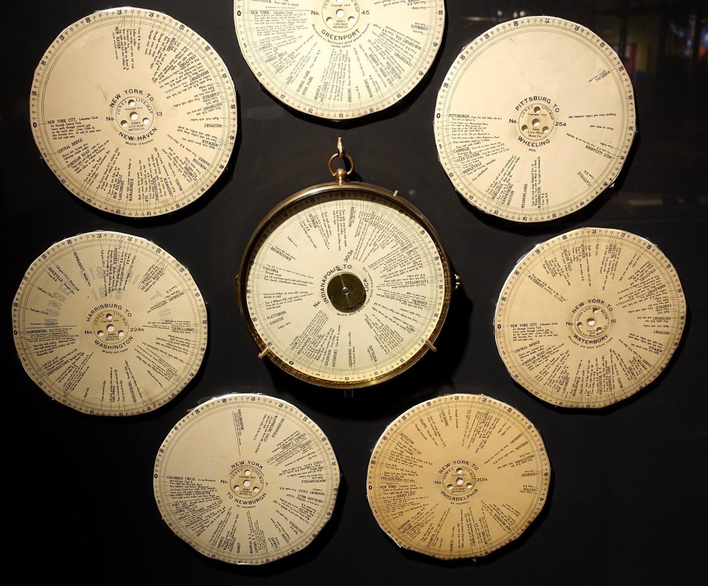
It was marketed as the Jones Live-Map, and described as:
“…the phonograph of the road. It has disc records covering the roads of the entire world. You insert the record of the trip you want to make. The Live-Map “plays” it. Not out loud, but with a pointer that always points the way—that tells you where you are now and what to do about it.
“To have it with you is like having in your car a man who knows every road, every corner, every crossing, every landmark, every puzzling fork and crossroad in the entire world.”
The Saturday Evening Post, quoted in Nillson, 2012
Be warned!
The Chadwick Road Guide was another system. It used route discs too but it also included a signal – a bell combined with colour coded symbols on the route directions – to indicate to motorists that directional choices were coming up and warn of potential hazards.
Lee S Chadwick, explained in his 1910 patent application:
“ the object of my invention is to provide an automatic guide or signal for use on automobiles and other vehicles; such device being designed to render automobile touring easier and safer than is possible by the use of touring books or other devices….
“…the signaling means forming the subject of my invention are far superior to any printed directions that have to be examined and selected while driving at speed, and when employed an operator does not have to rely upon his companions for road directions.”
Google Patents
These were the directions given by the symbols:
- Continue straight ahead
- Crooked road ahead
- Bad road, water crossing, or bridge ahead
- Turn sharply to the left
- Bear to the left
- Danger, go slow
- Speed trap, go slow
- Railroad crossing ahead
- Bear to the right
- Turn sharply to the right
(French, 2006)
Speaking the way
Meanwhile George E Boyden, of New York City, came up with a machine to speak the route directions, which he submitted for a patent in 1914.
“My invention relates to signaling apparatus for vehicles, and its object is to provide means for announcing to the driver of a vehicle such as an automobile, the directions for following a predetermined route….
“Suitably mounted on a base are a phonograph of any suitable type and a device for controlling the same, so. that the talking machine at the proper times will announce the directions whereby the driver will be enabled to follow a predetermined route.”
Google Patents

There were lots of other accessories intended to make driving easier, for example, displaying maps in a rigid frame clipped to the dashboard or a roller map that you could wind on as you drove. But the last of the direction guides that upated automatically using the progression of the car seems to have been the Iver Auto, developed in Italy in the 1930s, and shown in this video.
Adoption
An obvious limitation with all of these systems was you had to stick to the route but the system couldn’t tell you if you’d made an error. Likewise, if you decided to take a detour, you’d need to reset the machine manually once you were back on the route.
In May 1906, Scottish Field was dubious that the Kartograph would be popular, suggesting that “Even if the invention were brought to the commercial stage, it is doubtful if many would adopt the device….”
However by 1919 the Jones Live-Map system had expanded to offer over 500 routes, spanning the USA from New York to Los Angeles. But its adoption was short-lived. By the 1920s better roads and more standardised road signs meant finding your way as an ‘automobilist’ in the USA had become much easier and the system was no longer as useful. (Nilsson, 2012).
Digging into this unexpected topic has been fascinating, and given me new insights into thinking about how people respond to new technology, creating supporting accessories and gadgets for changing times.
There’s the class element too. The first cars were very expensive and so it’s not surprising that magazines like Scottish Field, aimed at the wealthy, leisured aristocratic class, started publishing articles on motoring.
This topic has introduced me to using patent documents – a source I’ve not encountered before – and what kind of information they can hold. And it’s fascinating that issues of class, and of gender, can be seen there too, in the references to the roles of owner and chaffeur in the Linden-Thaler and Protz patent, and in the Jones illustration where the uniformed chaffeur hands the Jones Live-Map device to the female passenger; presumably she or her husband employ him to do the driving. Apparently, George Boyden actually worked as a chaffeur (Printz, 2020).
Both the patents and the marketing materials emphasise how these directional tools offer independence. Firstly to the owner of a vehicle – who perhaps may not be able to drive – and is reliant on their chauffeur’s capabilities to judge the way. And, secondly, they free travellers of the necessity to ask strangers for directions.
It’s what I love about archives; the way that just a small paragraph in an old magazine can propel you into a whole new view of the past. Archives are windows, enabling us to glimpse how people interacted with their changing world and navigated new experiences.
Sources
- Scottish Field, May 1906. Consulted in Special Collections, Mitchell Library, Glasgow.
- Monmonier, Mark (2017) Patents and Cartographic Inventions: A New Perspective for Map History, Palgrave https://link.springer.com/book/10.1007/978-3-319-51040-8
- Alvarez Leon, Luis F. (2019) How cars became mobile spatial media: A geographical political economy of on-board navigation, Mobile Media & Communication, Volume: 7 issue: 3, pp: 362-379 DOI: 10.1177/2050157919826356
- French, Robert Lewis (2006) Maps on wheels: The Evolution of Automobile Navigation. In Akerman, J. R. (Ed.), Cartographies of Travel and Navigation (pp. 260–290). Chicago, IL: University of Chicago Press. Published online 2013 DOI: 10.7208/chicago/9780226010786.003.0007
- Lindenthaler, Frank J and Protz, John, Route-indicator for automobiles, Google Patents https://patents.google.com/patent/US915976
- Jones, Joseph W, (1909) Combined road-map and odometer, Google Patents , https://patents.google.com/patent/US1040345A
- Jones Live-Map catalogue, WorthPoint https://www.worthpoint.com/worthopedia/1920s-era-catalogue-jones-live-maps-1937485777
- Jones Live Map device and discs, Seal Cove Auto Museum https://www.sealcoveautomuseum.org/collection-test/jones-live-map/
- Chadwick, Lee (1910) Signaling device, Google Patents https://patents.google.com/patent/US1180239A
- Boyden, George (1914) Vehicle signalling system, Google Patents, https://patents.google.com/patent/US1168053A
- Nilsson, Jeff. (2012) The First GPS: High-Tech Navigation in 1909, The Saturday Evening Post
- Printz, Larry (2020) Turn-by-turntables: How drivers got from point A to point B in the early 1900s, ARS Technica
- Dempsey, Caitlin, Before there was GPS (2019) Geography Realm YouTube

_-_DSC06690.JPG)